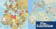
African Union joins calls to end use of Mercator map that shrinks continent’s size
African Union joins calls to end use of Mercator map that shrinks continent’s size

www.theguardian.com African Union joins calls to end use of Mercator map that shrinks continent’s size
Member states back Correct the Map campaign that urges governments and organisations to use more accurate map

