Search
StreetComplete: Can a inherently rough surface (like sett) ever be "almost seamless"? How do you rate surface qualities?
I'm often unsure how to rate the surface quality of an inherently rough surface, like sett, paving stones or cobble stone.
Question 1: These surfaces are defined by having seams. So would it ever be right to rate them as 'seamless'?
Or should we rate them as 'seamless' when they only have the expected amount of seams? Especially cobblestone makes me wonder, which usually comes with large seams and a rough and irregular surface.
---
Question 2: Tactile paving for blind people. Does that make a surface rough for you? In a way, that's literally how this paving becomes tactile, right?
---
Question 3: A pedestrian crossing going over a traffic isle (but marked as one continuous path). Assuming otherwise perfect surfaces, does it have 'cracks' (since it goes over 4 curbs), and a 'rough surface' if it has tactile paving?
---
Question 4: The marked entitiy is a wide area, not a narrow path. You're asked to rate it's surface quality. The area is mostly flat and smooth, but has some cracks and potholes in a few localized spots.
Do you mark it as 'a little bumpy' because that's how it would feel if you walk/bike over the bad spots? Or do you mark it as 'perfect', because it's easy to find a way through without encountering any obstacles?
OpenStreetMap congratulations to all the mappers, contributors and donors who made this journey possible. Strong map community 💪 🌎
OpenStreetMap congratulations to all the mappers, contributors and donors who made this journey possible. Strong map community 💪 🌎
\#HappyBirthdayOSM #WeAreOSM #SupportOSM #FreetoMakeNotFreetoBuild #OpenStreetMap @openstreetmap @openstreetmap@lemmy.ml @OSM\_Pontarlier @OpenStreetMapUS @osm\_foss
Exciting Update: Mapilio Now Integrated with OpenStreetMap iD Editor! 🌍
Exciting Update: Mapilio Now Integrated with OpenStreetMap iD Editor! 🌍
Dear Mappers,
🎉🎉 We're thrilled to share some exciting news 🚀 – Mapilio is now seamlessly integrated with OpenStreetMap's iD Editor! Your contributions on Mapilio are now easily accessible and editable through the iD Editor, making collaborative mapping more efficient than ever.
@openstreetmap @openstreetmap@lemmy.ml @OpenStreetMapUS @OSM\_Pontarlier \#osm #openstreetmap
📲 Is there a good alternative to StreetComplete for iOS users? Tips for getting started with mapping (Every Door, MapComplete, ...?)
I am currently collecting tips for easy entry into mapping. One of the top recommendations is of course StreetComplete, which is available for Android.
iOS users keep asking for something comparable for their OS. For an equally simple start with OSM, there is Every Door, which is also available for iOS. It's a very good app, but it really doesn't have the fun factor of StreetComplete and the UI is likely to scare off iOS users in particular.
There is also MapComplete, which can be used as a web app.
Do you have any other recommendations or ideas for iOS-Users?
Plan a running route with these 5 free run planner websites
Plan a running route with these 5 free run planner websites
https://www.ilovefreesoftware.com/06/featured/plan-a-running-route-free-run-planner-websites.html.
Unsurprisingly, 3 are using OpenStreetMap data.
This also means you can correct and add paths yourself if you ever notice some are wrong or missing.
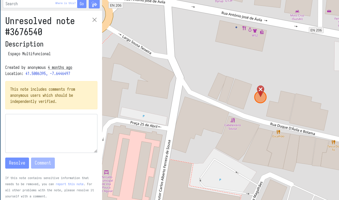
Deal with multi-functional place
I have a question, I think its kinda complex how to map it.
Here there is a multifunctional place (can receive a variety of events), when there aren't any events its a parking lot.
How should I map this "parking lot" (see image, its located in the note)?
Ignore the fact that it can receive other events and simply mark it as parking lot ?
OpenStreetMap Foundation launched consultations on their strategic plan v2.
OpenStreetMap Foundation launched consultations on their strategic plan v2.
You can provide your ideas and inputs via the community forum or on the mailing list.
https://blog.openstreetmap.org/2023/08/18/for-community-consultation-osmf-strategic-plan-v-2/
Exciting Update: Mapilio Now Integrated with OpenStreetMap iD Editor! 🌍
Exciting Update: Mapilio Now Integrated with OpenStreetMap iD Editor! 🌍
Dear Mappers,
🎉🎉 We're thrilled to share some exciting news 🚀 – Mapilio is now seamlessly integrated with OpenStreetMap's iD Editor! Your contributions on Mapilio are now easily accessible and editable through the iD Editor, making collaborative mapping more efficient than ever.
@openstreetmap @openstreetmap@lemmy.ml @OpenStreetMapUS @OSM\_Pontarlier \#osm #openstreetmap
Announcing State of the Map 2024 in Nairobi (and online) on 6-8 September 2024
Announcing State of the Map 2024 in Nairobi (and online) on 6-8 September 2024
What is this portion in OSM adresses?
I am a regular Osmand user, but I don't know much about how OSM works in detail. I noticed that in some services that use OSM, addresses appear like in this screenshot.
This second part of the address often has interesting names that I've never heard even for places I know well.
To me it looks like the name of a Gemarkung or something similar.
- What's the correct term for this part of an address?
- Where is this data derived from?
- Is it possible to show a map with the borders of these Gemarkungen (or whatever it is called)?
Also glad if someone can point me to the docs where I can read about this. I browsed the wiki but couldn't find what I was looking for.
Also interested about the correct terms for the other parts of the addresses.
Thanks!
(https://en.osm.town/tags/OpenStreetMap) Belgium’s Mapper of the Month (https://en.osm.town/tags/MotM) is (https://en.osm.town/@joost_schouppe).
\#OpenStreetMap Belgium’s Mapper of the Month #MotM is @joost\_schouppe.
If the name sounds familiar to you, it might be for many reasons. It could be for his past involvement as OpenStreetMap Foundation #OSMF board member, for leading the Belgian community chapter, or being a very active mapper.
Read the interview at https://openstreetmap.be/en/motm/2023/08/01/joost-schouppe.html.
cc: @openstreetmap
Baaj Nwaavjo I'tah Kukveni?
OpenStreetMap is a map of the world, created by people like you and free to use under an open license.

Just wondering if we have a polygon for this place which is in the news today?
Wie werden solche Wege in (https://gruene.social/tags/Openstreetmap) getagged?
Wie werden solche Wege in #Openstreetmap getagged? How to tag this path? \#Surface? \#Tracktype? \#Smoothness?
Der Weg ist im Wohngebiet und für Fußgänger\*innen und Fahrradfahrer\*innen freigegeben. Aber es ist nicht nicht festgelegt, wer wo gehen/fahren soll.
@openstreetmap @osmberlin @wochenaufgabe #OSM #OSM\_Deutschland #OSM\_de
Does anyone know what's going on with the CyclOSM layer?
I much prefer the clarity of bike infrastructure on the CyclOSM layer over Cycle Map.
But recently, it seems to either be blank (literally no map shows up) or it comes up as a basic map with no cycling infrastructure highlighted (i.e. if you are using brouter).
Even the official website isn't right.
Does anyone know what's happening?
Interesting paper from (https://en.osm.town/tags/MDPI) about “Mapping with (https://en.osm.town/tags/ChatGPT)” concludes it delivers unique advantages, such as:
Interesting paper from #MDPI about “Mapping with #ChatGPT” concludes it delivers unique advantages, such as: \- lowering the barrier to producing maps \- boosting the efficiency of massive map production \- and understanding geographical space with its spatial thinking capability.
Limitations cited are: \- its unequal benefits for different users (need to have some expertise already) \- and necessary user intervention for quality control.
https://www.mdpi.com/2220-9964/12/7/284
cc: @openstreetmap
From list of POI to bike-optimized itinerary?
Hi! How would you calculate an itinerary going through 20-25 points optimized for going over there by bike?
I have a list of points of interest in a KML file which I’d like to visit, so I’d like to calculate an itinerary optimized for bike (avoiding high-traffic roads).
I was able to import it in MapQuest which can calculate and optimize an itinerary but only for a car.
I also found Brouter can calculate an itinerary for bike but it cannot optimize (and the optimal order of POI calculated by MapQuest is not ideal for a bike trip).
Also, I was able to import the POI in Brouter, but I couldn’t find how to calculate an itinerary from that (I had to click again near each imported POI on the map, which is tedious, of course).
Do you know of a good solution to this?
TIA
Linux Group Shares Its First Open Dataset for Creating Real Google Maps Alternatives
If you’re not Google (or, to a much lesser extent, Apple), map apps are damned hard to make. Last year, several major heavy hitters in tech, including the likes of Meta, Microsoft, TomTom, and Amazon, decided to lay down their arms and meet under a flag of parlay held aloft by the Linux Foundation to make mapping just a little easier, cheaper, and less dominated by two companies. Alone, none could establish a big enough data pool to rival the likes of Google Maps, but with their individual hoards of business location data, satellite mapping tech, and more support from smaller tech firms, they could perhaps gather enough data together to help create a whole new series of up-to-date map apps.
On Wednesday, this pooled initiative, called the Overture Maps Foundation, shared its first alpha release for its mapping data. It contains millions of examples for buildings, roads, and geographic boundaries. It’s only the first large release for the planned massive dataset, but the hope is there will be much more to come as companies sign on.
Marc Prioleau, the executive director of the Overture Maps Foundation, was named as head of the project back in May. He’s been around mapping projects for many years, having worked in the start of the GPS market back in 1995, and later moved on to the likes of Meta and Uber for their location-based services. He said if there’s one thing that strikes at the difficulty of building a high-quality app with exacting road and place information, it’s the ephemeral nature of public infrastructure.
“The hardest thing in mapping is knowing what’s changed in the world,” Prioleau told Gizmodo in a video chat. Essentially, map apps are some of the hardest to design simply because of the massive amount of data required to build the systems. Not only do they need to be accurate, but they need to be constantly updated when businesses close and new ones open.
The first Overture release contains about 59 million points of interest that the group claims has not yet been released as open data before. A POI could be anything—a public landmark, a specific building, or a local business. Otherwise, the data contains about 750 million building footprints alongside road data that’s mostly collated from the crowdsourced OpenStreetMap project.
So how much of the world does this alpha release truly cover? Prioleau said the POI data makes up around 60 to 70% of a worldwide dataset. In his mind, a good number to shoot for is somewhere between 80 and 100 million places. It’s something of a Goldilocks problem. With around 200 million POIs, Prioleau said you’d likely be hoarding a lot of “junk,” but too little means you’re obviously missing out on locations, especially from less represented countries.
As far as the building data, he said that “feels pretty complete” as far as laying out worldwide structures, considering that the U.S. itself contains something around 100 million buildings. A good chunk of that data came from Meta through businesses listing their addresses on Facebook or Instagram. Microsoft also handed over some of its data through its work on Bing Maps, but the two sets combined included duplicates, which cut down on total numbers. The Overture director said the foundation has plans to add more datasets in the future from other sources centered on different continents.
The road data is a different beast entirely. The vast majority of it is based on the OpenStreetMap project, an open source, wiki-style resource compiled by internet users going on nearly 18 years. Prioleau said Overture has modified the project’s info to make it easier to attach new datapoints. The project has also worked to standardize and fact check the data contained on the project’s site. There’s also several benefits to using this Wikipedia-style map compared to how Google might spend billions maintaining its map data every year (or otherwise buying up the competition like it did with Waze). Users on the ground can archive and modify the map to note damage during a natural disaster.
“One of the things [OpenStreetMap] does incredibly well is build richness into the map, because what you map is no longer determined by what your commercial interest is, it’s what the community wants to map.”
Prioleau described himself as “the only full time employee” of the Linux Foundation-based group. Otherwise, the Foundation has depended on around 130 engineers from Meta, Microsoft, and more of the steering companies. As far as maintaining the data, the Overture head said that there’s no contractual agreement for companies to use the open source resources, but they’re still heavily encouraging all those who build upon their foundation to somehow give back to the data source with any new information they collect.
“The incentive is: if you want to fork [AKA build off] Overture, start building your own dataset and not give stuff back, then you’re on your own to maintain that dataset going forward.” Prioleau said. “So the incentive to giving back is that your data remains part of this consortium.”
What’s next is to create a “global entity reference system” for attaching data points to a map, which will then facilitate even more layers of information for new apps. Today’s map users aren’t just looking for ways to get from place to place, but from door to door. Delivery drivers need to know where they can pick up and drop off items. People with disabilities want to know where they can find ramp or elevator access.
“Maps are really digitization of things that are observable,” the Overture lead said. “We’re not mapping secret stuff. We’re mapping roads and addresses and places—things that are observable. And as the ways of capturing observable stuff gets better, the ability to build maps gets better.”
Links: gizmodo.com/your-phones-navigation-app-is-probably-smarter-than-you
https://gizmodo.com/iphone-find-my-apple-maps-mistake-houston-house
gizmodo.com/linux-google-maps-meta-aws-microsoft-tomtom
prnewswire.com/news-releases/overture-maps-foundation-names-marc-prioleau-as-executive-director
gizmodo.com/why-google-buying-waze-will-keep-you-out-of-gridlock
🛴🔌 Unless anyone objects, I'm going to suggest we map these things as
🛴🔌 Unless anyone objects, I'm going to suggest we map these things as
amenity=escooter\_rental capacity=\<int\> escooter\_rental=virtual network=Voi
www.openstreetmap.org/node/110… #OpenStreetMap #Oxford \#openstreetmap, #oxford
---
👉 (https://www.weeklyosm.eu/archives/16605) 👈 Issue 678 of weeklyOSM is out. 🌏 涵蓋 (https://en.osm.town/tags/%E9%96%8B%E6%94%BE%E8%A1%97%E5%9C%96) (https:/
👉 www.weeklyosm.eu/archives/1660… 👈 Issue 678 of weeklyOSM is out. 🌏 涵蓋 #開放街圖 #osm 世界大小事的新一期 weeklyOSM 已經發佈 🚀 Lisez les dernières nouvelles de l'univers #openstreetmap 🗺️ Viele Neuigkeiten aus der #osm Welt 📰 新一期的OSM周刊已经发布 🌏 Se ha publicado un nuevo número del semanarioOSM 🌐 最新の週刊OSMが発行されました。⛩️ 주간OSM 최신호가 나왔습니다 💬 Тижневик OSM тепер доступний Українською 📲 \#開放街圖, #osm, #openstreetmap
---
What (https://urbanists.social/tags/OpenStreetMap) people are near (https://urbanists.social/tags/Oxford) (https://urbanists.social/tags/UK)? There's loads of things that
What #OpenStreetMap people are near #Oxford #UK? There's loads of things that need updating. Let's see if we can organise something over the fedi!
(boosts appreciated, sorry for the # and @ spam) @openstreetmap@en.osm.town @openstreetmap@lemmy.ml @openstreetmap@a.gup.pe
Though I believe StreetComplete may re-ask some quests after some time to confirm stuff like opening hours is still up to date.
Yes, some quests have a resurvey interval. I also noticed I can change between often, normal and rarely (or something like that) in my personal settings. Not sure what the exact algorithm is, but resurveying is a thing.
If you would prefer this offline there's a "community style" for OsmAnd that goes for a very similar look here:
https://github.com/OsmAnd-Rendering/Cycling/blob/main/README_EN.md
This is how I do it with iD and Relatify:
- Create all the bus stops in iD (that includes the bus stop sign location, and (importantly!) the bus stopping location on the road)
- Create a relation using iD using only the first two or three bus stops.
- Use Relatify to finish connecting the rest of the stops.
@MrMusAddict @pootriarch within OSM, it's easy to add a tag like that. Alas, it's getting data users to _use_ that tag can be tricky...
@Synnr I haven't used Waze. But @organicmaps is great
It's an alternative, but provides no new functionality. The truth is while owned by Meta, Mapillary has the best street imagery coverage of all three street view platforms. I provided millions of images for all platform so far, but here's some feedback.
If I had to rank them:
- Mapillary integration with iD and JOSM and has the most configuration options and most active community. I dislike supporting any Meta platform, but for OSM's sake I think this platform works the best.
- KartaView, which also has nice integration with iD and JOSM, but the community is smaller and the coverage is not as thorough.
- Mapilio is the latest, but for now I don't see any new features and we are yet to see how this platform develops and how adoption works.
Fortunately all three platforms are integrated into iD, so editors have the option to use whatever works and has coverage for the area.

@Synnr The amount of people who have contributed to OpenStreetMap, to the map data, is massive. More than >2,000,000 people, and about 50,000 people edit the map every month.
Which app did you try? OSM is a little decentralised, so there are many.
@MistaJostur @notExactlyI20 IMO that's the best way right now. Once you've added all the stops, and in order to create the route, give Relatify a try. I've had good echoes about it
@Synnr looks like photos from State of the Map conferences.
@toaster @une_abeille Not sure what people are looking for in those, what criteria are you interested in?
@une_abeille Panoramax is the only solution that I know of right now. Developped and driven by the french OSM community, planning to support federation being instances. You can see and test a live demo at panoramax.openstreetmap.fr
@bysariipek @unsaid0415 @mapilio Pretty sure that Mapillary started that way too
Mapilio: The map editor superhero. It helps users edit and enhance map data, and it's now teamed up with OpenStreetMap's iD Editor for seamless collaboration. Plus, it's powered by a UK-based nonprofit yet company.
Mapillary: A street-level imagery company owned by Meta (formerly Facebook). Different heroes, different backgrounds! 😉
@InsertUser @Doudouosm And all three of them (and trailrouter) use GraphHopper for routing :)
I think Trail Router is the simplest OSM based "give me a route" tool.
Closest thing is probably Back of Your Hand.
There is also Comparison of iOS applications
I agree, though I don't see the repository for this on his github account.